There's no better way to see the world than on a bike. Join me on my rides around Europe to discover what lies beyond my handlebars

Monday 28 September 2015

Trust your brakes? Absolutely?

The Cols are not as high as in the Pyrenees - but the weather is better
Do you trust your brakes? Trust them absolutely? How do you feel about a 10% descent: huge drop off on your right, jagged rock wall left, sharp bends, no barrier?

A crack where the sun never shines?
Cycling in the southern Cevennes, south-central France. Heart pumping climbs. Heart stopping descents. Breathtaking views. Gigantic drops. There are endless tiny roads, little traffic but coffee bars are scarce.
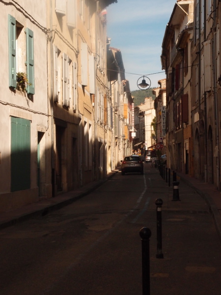
St Jean du Gard

The cols are not as high as in the Haute Pyrenees: 500-600m But the weather is better. 300 days of sunshine a year. The challenges are just as great.
 
Swirling curves
Two rides completed in the area this year en route from the rain-swamped Pyrenees. Base is Anduze. Take the high road to St Jean du Gard. Streets in the town are so narrow, the houses so tall, the road must be in permanent shadow.

Tiny communities buried deep n the broadleaf forests
Head out of town and at the fork take a right: a long, steady, winding climb through broad-leaf forests to Col D’Uglas at 529m. Down past tiny, ancient communities clinging to the hillsides to the busy town of Alés. Friday prayers have just finished. Cars everywhere. The road round town is a bumpy, gritty mess. Then a smooth hill on a broad bike lane, up and over to Anduze.

Day 2, same road out of St Jean but left at the fork and cruise to St Etienne. Typical French mountain road, low wall, swirling curves, swooping drops and swift climbs. A great coffee in a roadside bar in St Etienne before backtracking and take the fork to Moissac. A painful, grinding climb to the Corniche de Cevennes road. It is 2km along this fast highway to another col – Col de l’Exil. Instead we choose a tiny road – here, the dramatic drop into the Gordon Gorge at Saumane.
 
Steep hills, big drops, no wall

It’s narrow, steep, winding and there’s next to nothing to stop us falling off the edge. Instinctively we moved towards the centre. The brakes are good, we make it down. Ahead is another col, extra steep and with warning signs. Instead, we turn left on a glorious road along the gorge. Smooth. Gently downhill. Brisk wind at our backs. Pause to watch some canyoning. Cruise into St Jean de Gard. Coffee.
 
The Day 2 profile - a painful climb and then exciting descent
Log
Day 1: 58km 934m climbing
Day 2: 50km 1077m climbing

Coffee
Le Bistrot, St Jean du Gard. Deux double - €5

Brakes
Avid BB7 cable-operated disks – trust them absolutely

You said it!

The landscape speaks – are you listening? – William Least Heat Moon
The Gardon Gorge
Cyclists are dwarfed by the scenery along the gorge


Monday 21 September 2015

Pyrenees 3: in the tracks of Le Tour


Each year for the past few years we have pedalled up one of the climbs taken that year by the Tour de France. We've done it in the Alps, the Vosges, Provence and in the Pyrenees. Climbing the classic routes in the wheeltracks of the mighty, seeing their names painted in the road as we near the top. It’s emotional. We can do it too, albeit slower. 

These climbs all have their own moments of history which come to life as we struggle upward. Rounding the last bend on the Alpe d'Huez, Pantani's collision with an over-zealous amateur photographer becomes almost real. Topping the Ventoux, the agonies of Tommy Simpson's collapse. Other great moments come to mind. Indurain's amazing breaks on Pyrenean climbs. The exhaustion, the exultation, the pain, the disappointments.


Take a look in Wikipedia. You will see the importance of the Tour to these small Pyrenean towns and communities. Most entries are limited to location, the decline of population and history which largely amounts to: 2008 Tour de France stage 18 start. 2011 Tour de France passed through. Their whole history is related to visits by the heroes of cycle racing.

This year we chose the Col de la Core. Not one of the toughest category climbs but the Peloton passed through in July on its way to Plateau de Beile -  much higher than our 14km, 1395m pass. 835m higher than the start at Castillon.

We have different ways of dealing with the process of getting to the top. One of us, the mathematically minded, counts pedal revolutions, measures the remaining distance to the next kilometer marker, notes the angle of climb (and sometimes groans), calculates the altitude climbed and how much remains. The other thinks about what should go in the day's blog, looks out for photo opportunities - blanks out all the distances, heights and angles.


Col de la Core has a maximum angle of 7.5% and though it isn't particularly high, breaks out above the tree line, giving it the feel of a much higher classic Tour pass. As we ride, the muscley-legged locals spin past with "bonjour", "allez" and "courage" and before long some are whizzing by in the other direction, but always greeting our progress.


It is easy to picture the Tour caravan here, the cars and motor caravans lining the road. The fans in all sorts of fancy dress and undress.  The pungeant smell of hot bodies and sun lotion. Flags. Shouts. Clapping. Passion. The riders punching their way through what looks like a wall of humanity. There's hardly a soul as we reach the summit.

Round the final bend, it's almost flat, the sign comes into sight, the finish line! And as one of us arrives, a small round of applause from the local cyclists. It is such a great feeling!

Back in Castillon, a double espresso in the only bar sets us up for the drive back to Foix. 


Log
33km. 898m climbing

You said it!
“It’s just a bike race after all” – Miguel Indurain after winning his fourth Tour de France


The view back to the start in Castillon

Friday 18 September 2015

Pyrenees 2: A rest day?

The French don't go in for bike paths much. Not like the Germans and Austrians with their heavily signposted long distance trails separated from the traffic.

There are a few routes in France, following small roads with a signpost at most junctions - except some critical ones where a wrong turn will cause you to race down a hill before you realise it's the other way. The 270km circuit of the Luberon mountain in Provence is a good example.


Most of the time in France we take to the small roads. The country is heavily laced with these. Reasonable surfaces. Reliable signposting. Little traffic. The pleasure of discovery. The pain of finding a long and unexpected climb. The yellow Michelin 1cm to 1.5km maps are ideal. Even the narrowest lanes are accurately marked.

Day 2 in the Midi Pyrenees. This is going to be an easy, relaxing ride in the foothills. There's a green route bike path from our base in Foix to St Girons. 42km along a former railway. But how to find the start? A few signs would help as its 5km out of town. Like most former rail tracks the gradient is easy. Here the surface is packed clay with a coating of fine grit.
Lake Mondely 
Before long we leave the Voix Verte and head out on the country lanes. A long, long gradual descent and a tail wind. We are going to pay for this later. Turn left on a tinier lane, wind up to a view of a lovely lake far below. The map shows a rasta-hair road, curly and tangled. Steeply down to a beach for lunch on a bench watching the swimmers. This is Lake Mondely sandwiched between folds of steep green wooded hills. Then the reckoning. A long climb, not too steep but on a road that the council must have forgotten because the surface is broken, patchy, holey.

Down to La Bastide and rejoin the bike path. It's pretty tedious. A long, straight, flattish yellow trail. If you ride the whole 40km to St Giron, what then? Turn round and ride back? 


Occasional fine views across the hills to the great sweep of mountains beyond. It puts me in mind of Robert Pirsig's iconic 1970s book Zen and the Art of Motorcycle Maintenance. He writes about how much better the unrestricted view is from his "cycle" compared to the landscape when framed by the view from a car.  I agree. The unrestricted view from my cycle of the distant Pyrenean peaks should and could never be framed.

At the point where we joined the trail early in the day it carries on. We ask. "Yes it continues to Foix". But the surface is rough. We cross a viaduct and continue till we reach a road of sorts. No signs. The road peters out but a track leads up to the right and brings us to the road we left town on. 
 
Rest day profile!
Cruise down to town. Café du Commerce. A grand café creme sets us up for the final few km. This was meant to be an easy day. Nothing is certain when we follow a route we planned on a map. We like it that way.

Log
62km, 700m climbiing 


Coffee
Café du Commerce. Grande Crème €2.50 – not bad at all

You said it!
Your eye for geography grows sharp. Your legs attend the lost world of contours, the dales and hills that are ironed out by internal combustion.

Chip Brown, A Bike and a Prayer

Wednesday 16 September 2015

Pyrenees 1: A three-col day

Long shadows as we set off. It's 8.30am. We are a long way west of home. And further south. The Pyrenees.  Mountains with a difference. Different to the Austrian Alps back home.

The cycling culture is different too. More respect from car and truck drivers. More respect from just about everyone. Local authorities included.  Climbing cyclists even get special road signs.

There's no other way to get here but driving 1500km across Italy and France. The bikes bouncing on the rear towhook in all weathers. 

Day one after the long drive. Out through Foix at 370m and on to the D17 direction Col de Marrous. At first it is busy but soon just the occasional car passes us.

The col is not one of the big famous ones. But even so, we come to a big sign indicating the average and maximum steepness, the length of the climb and the altitude to be gained. For this and the col beyond. Col de Peguére.

Pyrenean climbs are long and steady. Do-able. Even at our age. We climb almost 30km. Maximum steepness is 8%. The last few kilometers are 3% or less. At every kilometer, a sign tells the altitude and the steepness of the next sector.

Barrets: A bronzed old guy standing in his doorway offers an approving Bonjour. Then another as we pass through the village. Local cyclists with knotty, leathery calves nod greeting as they fly past down the hill. Anyone on a bike of any sort, tackling the cols, deserves respect.

Col de Marrous, just under 1000m. Then the road winds onward and upward through mixed woodland. Bright sun then deep shade. Great views of wooded mountains and out to the flatter land to the east.

Its a good day for Col collectors (col-lectors?) as we pass the sign announcing Col des Jouels at 1247m. Only two more kilometers to Col de Peguére at 1375m.  At the top is a stunning panorama directly ahead. Mountains up to and above 3000m.

The road drops away. Descent at 18%. Glad we didn't come up that way, we turn and cruise down back to Foix and coffee.


Log
Foix - Col de Peguère - Foix 61km
1,112m climbing

Coffee
Foix. Cafe Gros: Double espresso in the town centre €2.50 each. Small bottle of water €3. They've got the balance about right.

You said it!

The world lies right beyond the handlebars of any bicycle – Daniel Behrman, The Man Who Loved Bicycles